

Sebastian Barros: Using telecom networks for weather sensing requires a strategic telco shift from connectivity providers to ecosystem orchestrators
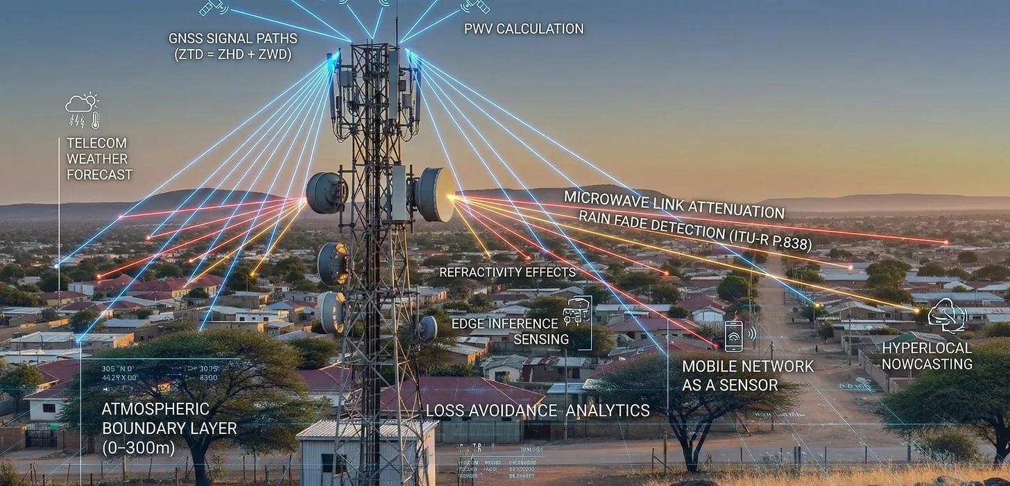
Telecom networks for weather sensing can be facilitated by using existing microwave links and 4G/5G signals as virtual sensors, detecting changes in signal strength and timing caused by rain, humidity, and temperature, effectively turning vast infrastructure into a dense, real-time atmospheric monitoring system for improved forecasting and disaster alerts, notes Sebastian Barros on Substack. By analyzing signal attenuation, telecom networks create high-resolution weather maps, complementing traditional methods like radar. Yet very few network operators or vendors have attempted to use telecommunications infrastructure for dense atmospheric sensing. The data exists but is rarely activated, processed, or disclosed.
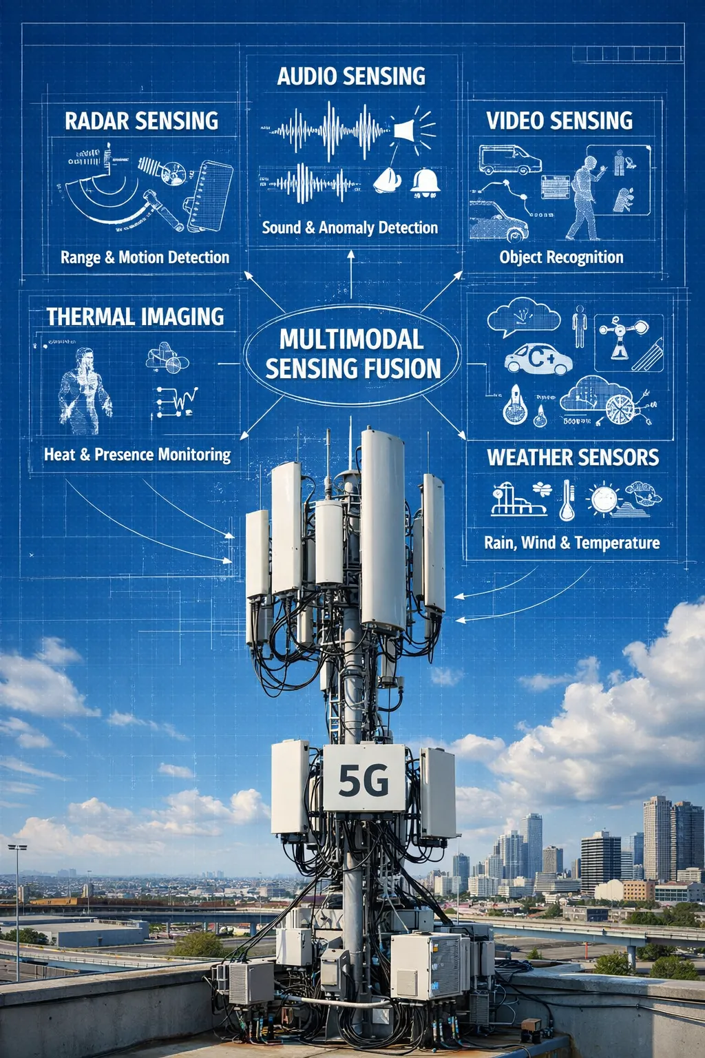
Global Navigation Satellite System (GNSS) [1.] based atmospheric estimation, rain attenuation on microwave links, and radio refractivity effects have been studied for more than 20 years. The physics is well understood and already embedded in network planning and synchronization systems. There are eight million radio sites span cities, roads, ports, factories, and borders. Every site has power, compute, backhaul, antennas, timing, and regulatory protection. Today, the network only provides connectivity. Integrated Sensing and Communication (ISAC) starts to change that. It repurposes radio waves for radar-like sensing, including presence detection, velocity, Doppler shift, and range.
……………………………………………………………………………………………………………………………………………………………………………
Note 1. Global Navigation Satellite System (GNSS) is the umbrella term for satellite constellations like the U.S.’s GPS, Russia’s GLONASS, the EU’s Galileo, and China’s BeiDou, which provide global positioning, navigation, and timing (PNT) services. GNSS receivers use signals from these orbiting satellites to calculate precise locations on Earth, offering increased accuracy and reliability compared to relying on a single system, enabling applications from smartphone navigation to autonomous vehicles and precision agriculture.
……………………………………………………………………………………………………………………………………………………………………………
- Receiver: Your end point receiving device (phone, car navigation, etc.) picks up signals from several of these satellites.
- Calculation: By measuring the time it takes for signals to arrive from at least four satellites, the receiver performs complex calculations (trilateration) to pinpoint your exact position.
Telecom networks can expose not just connectivity but structured awareness: object motion, crowd flow, anomalies, risks, and environmental state. In real time, across every continent. The infrastructure already exists. What’s missing is the architecture and the will to build the sensing layer on top of it. With dense, real-time sensing already in place, telecom can expose environmental intelligence through Open Gateway APIs, just as it exposes location or quality today. No new hardware. No new towers. Just activation, inference at the edge, and exposure.
- Data Siloing: The data produced by ISAC currently remains locked within the physical (PHY) and Media Access Control (MAC) layers of the network. It is primarily used for internal network optimization and is not exposed to external applications or platforms.
- Lack of Abstraction and APIs: There are no standard abstraction layers or Application Programming Interfaces (APIs) that would allow external systems (e.g., weather services, autonomous navigation systems, urban infrastructure management) to access and interpret the raw sensing data.
- Absence of Data Fusion Standards: There is no standard methodology to fuse the output from ISAC with data from other sensing modalities (e.g., vision, audio, thermal sensors). This prevents the creation of a comprehensive, multimodal sensing mesh.
- Missing Marketplace: The lack of standardized access and integration means there is no marketplace for this valuable data, which stifles innovation and collaboration across different industries that could benefit from real-world awareness information.
References:
https://sebastianbarros.substack.com/p/telecom-built-the-worlds-best-weather
https://sebastianbarros.substack.com/p/telco-network-as-a-sensor-is-a-huge
https://www.linkedin.com/feed/update/urn:li:activity:7413260481743769600/
https://www.euspa.europa.eu/eu-space-programme/galileo/what-gnss
2025 Year End Review: Integration of Telecom and ICT; What to Expect in 2026
Smart electromagnetic surfaces/RIS: an optimal low-cost design for integrated communications, sensing and powering
Deutsche Telekom: successful completion of the 6G-TakeOff project with “3D networks”