

Internet connectivity
Hurricane Electric establishes carrier neutral PoP at Lincoln Data Centers, Nebraska
Fremont, CA headquartered Hurricane Electric is a leading Internet backbone [1.] and colocation provider specializing in colocation, dedicated servers, direct Internet connections and web hosting. Hurricane Electric operates its own global network, running multiple OC192s, OC48s and Gigabit Ethernet. The ISP offer the following services:
- IP Transit [2.]: Wholesale internet connectivity ranging from 100 Mbps to massive network speeds over IPv4 and IPv6.
- Colocation: Physical rack and cabinet space in their carrier-neutral data centers (primarily in Fremont and San Jose, California) for customer-owned servers.
- Dedicated Servers: Single-tenant servers for businesses seeking dedicated safety, hardware, and performance.
- Web Hosting: Virtual hosting accounts for running and maintaining websites.
Note 1. Hurricane Electric claims to have the world’s largest IPv6-native Internet backbone. President Mike Leber founded Hurricane Electric in a garage in 1994. Hurricane Electric now operates an international backbone network and owns several datacenters, including a new 200,000 square-foot Fremont 2 colocation facility.
Note 2. IP transit is a commercial, wholesale service where an upstream Internet Service Provider (ISP) allows network traffic to travel through its backbone infrastructure to reach the rest of the global internet
Image Credit: Hurricane Electric
………………………………………………………………………………………………………………………………………………………………
Today, the company announced that it has established a new Point of Presence (PoP) at Lincoln Data Centers. The new PoP is located at 206 South 13th Street, Lincoln NE.
Lincoln Data Centers provides a carrier-neutral interconnection and colocation environment purpose-built for organizations with expanding connectivity requirements. The facility combines diverse fiber infrastructure, access to regional and long-haul carriers, low-friction interconnection through meet-me-room capabilities, and flexible deployment options that support scalable growth. Positioned in the geographic center of the United States, Lincoln Data Centers serves as an efficient regional hub for enterprises, cloud platforms, content providers, and network operators seeking resilient, low-latency connectivity across the Midwest and beyond.
The central United States continues to play an increasingly important role in digital infrastructure development due to its geographic advantages, expanding fiber ecosystems, growing enterprise technology adoption, and proximity to major population and business centers. Nebraska’s favorable business environment and central location make Lincoln an attractive market for organizations seeking resilient, low-latency connectivity and diversified network routes.
The new PoP improves fault tolerance, load balancing, and congestion management for next-generation IP connectivity services throughout the region. Customers of Lincoln Data Centers can now access Hurricane Electric’s extensive IPv4 and IPv6 backbone through 100GE (100 Gigabit Ethernet), 10GE (10 Gigabit Ethernet), and GigE (1 Gigabit Ethernet) ports.
“We are pleased to expand Hurricane Electric’s presence in the Midwest with this new Point of Presence at Lincoln Data Centers,” said Mike Leber, President of Hurricane Electric. “Lincoln’s central location, strong business climate, and growing digital infrastructure ecosystem make it an ideal site to support customers requiring reliable, high-capacity Internet connectivity across the region.”
With this deployment, organizations in and around Lincoln can exchange IP traffic directly with Hurricane Electric’s vast global network, which supports more than 40,000 BGP sessions with over 10,500 networks across more than 320 major exchange points worldwide.
The addition of this PoP reflects Hurricane Electric’s ongoing investment in expanding connectivity throughout North America and its commitment to delivering low-latency, highly resilient Internet connectivity for enterprises, cloud providers, research institutions, content platforms, and service providers.
About Hurricane Electric:
Fremont, California-based Hurricane Electric operates its own global IPv4 and IPv6 network and is considered the largest IPv6 backbone in the world. Within its global network, Hurricane Electric is connected to more than 320 major exchange points and exchanges traffic directly with more than 10,500 different networks. Employing a resilient fiber-optic topology, Hurricane Electric has five redundant 100G paths crossing North America, four separate 100G paths between the U.S. and Europe, and 100G rings in Europe, Australia and Asia. Hurricane also has a ring around Africa, and a PoP in Auckland, NZ. Hurricane Electric offers IPv4 and IPv6 transit solutions over the same connection. Connection speeds available include 100GE (100 gigabits/second), 10GE, and gigabit ethernet. Additional information can be found at http://he.net.
References:
From LPWAN to Hybrid Networks: Satellite and NTN as Enablers of Enterprise IoT – Part 2
By Afnan Khan (ML Engineer) and Mehsam Bin Tahir (Data Engineer)
Introduction:
This is the second of two articles on the impact of the Internet of Things (IoT) on the UK Telecom industry. The first is at
Enterprise IoT and the Transformation of UK Telecom Business Models – Part 1
Executive Summary:
Early Internet of Things (IoT) deployments relied heavily on low power wide area networks (LPWANs) to deliver low-cost connectivity for distributed devices. While these technologies enabled initial IoT adoption, they struggled to deliver sustainable commercial returns for telecom operators. In response, attention has shifted towards hybrid terrestrial–satellite connectivity models that integrate Non-Terrestrial Networks (NTN) directly into mobile network architectures. In 2026, satellite connectivity is increasingly positioned not as a universal coverage solution but as a resilience and continuity layer for enterprise IoT services (Ofcom, 2025).
The Commercial Limits of LPWAN-Based IoT:
LPWAN technologies enabled low-cost connectivity for specific IoT use cases but were typically deployed outside mobile core architectures. This limited their ability to support quality of service guarantees, enterprise-grade security and integrated billing models. As a result, LPWAN deployments often remained fragmented and failed to scale into durable enterprise business models, restricting their long-term commercial value for telecom operators (Ofcom, 2025).
Satellite and NTN as Integrated Mobile Extensions:
In contrast, satellite and NTN connectivity extends existing mobile networks rather than operating as a parallel IoT layer. When non-terrestrial connectivity is integrated into 5G core infrastructure, telecom operators are able to deliver managed IoT services with consistent security, performance and billing models across both terrestrial and remote environments. This architectural shift allows satellite connectivity to be packaged as part of a unified enterprise service rather than sold as a standalone or niche connectivity product (3GPP, 2023). Figure 1 illustrates this hybrid terrestrial–satellite model, showing how satellite connectivity functions as an extension of mobile networks to support continuous IoT services across urban, rural and remote environments.
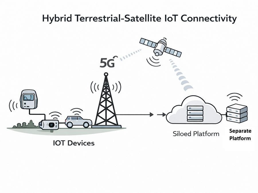
Figure 1: Hybrid terrestrial–satellite connectivity supporting continuous IoT services across urban, rural and remote environments.
Industrial Use Cases and Hybrid Connectivity
In sectors such as offshore energy, agriculture, logistics and remote infrastructure monitoring, IoT deployments prioritise coverage continuity and service resilience over peak data throughput. Hybrid terrestrial–satellite connectivity enables operators to offer coverage guarantees and service level agreements that LPWAN-based models could not reliably support. In 2026, Virgin Media O2 launched satellite-enabled services aimed at supporting rural connectivity and improving resilience for IoT-dependent applications, reflecting a broader operator strategy to monetise non-terrestrial coverage where reliability is a core requirement (Real Wireless, 2025).
The commercial implications of this transition are further illustrated in Figure 2, which contrasts siloed LPWAN deployments with integrated mobile and satellite IoT services delivered through a unified network core.
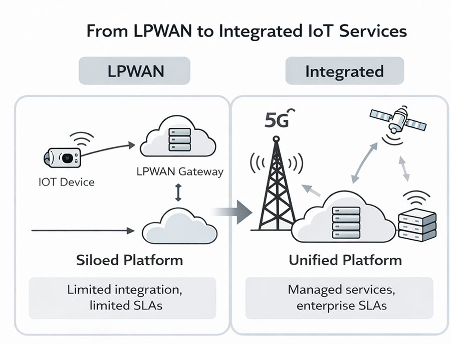
Figure 2: Transition from siloed LPWAN deployments to integrated mobile and satellite IoT services delivered through a unified network core.
Satellite Connectivity and Enterprise IoT at Scale:
The UK Space Agency has identified hybrid terrestrial–satellite connectivity as an enabling layer for remote industrial operations, environmental monitoring and agricultural IoT systems. UK-based firms such as Open Cosmos are contributing to this model by integrating Low Earth Orbit satellite connectivity with existing mobile core networks. This approach allows telecom operators to deliver end-to-end managed connectivity for enterprise customers without deploying separate IoT network stacks, converting coverage limitations from a cost burden into chargeable, service-based revenue opportunities (Open Cosmos, 2024; UK Space Agency, 2025).
Conclusion
In 2026, IoT is reshaping the UK telecom sector primarily by enabling new revenue models rather than by driving incremental network expansion. Following the limited commercial success of LPWAN-based IoT strategies, satellite and Non-Terrestrial Network integration is increasingly deployed as an extension of mobile networks to provide coverage continuity and service guarantees for industrial and remote use cases. When integrated into 5G core architectures, satellite connectivity enables telecom operators to monetise resilience and reliability as part of managed enterprise services rather than offering standalone connectivity. Taken together, these developments show that satellite and NTN integration has become a critical enabler of scalable, enterprise-led IoT business models in the UK (Ofcom-2025; 3GPP-2023).
…………………………………………………………………………………………………………………………………………………………………………
References:
Ofcom. (2025). Connected Nations UK report.
https://www.ofcom.org.uk
Real Wireless. (2025). Satellite to mobile connectivity and the UK market.
https://real-wireless.com
UK Space Agency. (2025). Connectivity and space infrastructure briefing
https://www.gov.uk/government/organisations/uk-space-agency
Open Cosmos. (2024). Satellite solutions for IoT and Earth observation.
https://open-cosmos.com
3GPP. (2023). Non-Terrestrial Networks (NTN) support in 5G systems.
https://www.3gpp.org/news-events/ntn
Non-Terrestrial Networks (NTNs): market, specifications & standards in 3GPP and ITU-R
Keysight Technologies Demonstrates 3GPP Rel-19 NR-NTN Connectivity in Band n252 (using Samsung modem chip set)
Telecoms.com’s survey: 5G NTNs to highlight service reliability and network redundancy
ITU-R recommendation IMT-2020-SAT.SPECS from ITU-R WP 5B to be based on 3GPP 5G NR-NTN and IoT-NTN (from Release 17 & 18)
China ITU filing to put ~200K satellites in low earth orbit while FCC authorizes 7.5K additional Starlink LEO satellites
Samsung announces 5G NTN modem technology for Exynos chip set; Omnispace and Ligado Networks MoU
ITU’s Facts and Figures 2025 report: steady progress in Internet connectivity, but gaps in quality and affordability
Overview:
The world’s online population grew by more than 240 million people in 2025, according to a new ITU Facts and Figures 2025 report. The new estimates confirm continuing progress in expanding digital connectivity, while pointing to differences in quality that impact how users benefit from Internet use. Globally, an estimated 6 billion people – about three-quarters of the world’s population – are using the Internet in 2025, up from a revised estimate of 5.8 billion in 2024. However, 2.2 billion people remain offline, down from a revised estimate of 2.3 billion in 2024. Overall, the report’s findings underline the importance of digital infrastructure, affordable services and skills training to ensure that everyone can truly benefit from advancing technologies such as artificial intelligence (AI).
“In a world where digital technologies are essential to so much of daily life, everyone should have the opportunity to benefit from being online,” said ITU Secretary-General Doreen Bogdan-Martin. “This report highlights how today’s digital divides are being defined by speed, reliability, affordability, and skills, all of which we must prioritize as we work toward our mission of universal connectivity.”
Connectivity’s quality challenge:
For the first time, Facts and Figures estimates the total number of 5G subscriptions, which now account for about one-third – or around 3 billion – of all mobile broadband subscriptions worldwide.
In 2025, 5G networks are estimated to cover 55 per cent of the world’s population, reflecting strong momentum in advanced mobile technologies. Coverage, however, remains uneven, with 84 per cent of people in high-income countries having access to 5G, compared with only 4 per cent in low-income countries.
While Facts and Figures shows that 4G and 3G services are available to most of the global population, these services are not best suited for keeping pace with advancing technologies.
Estimates in the report reveal deep contrasts in intensity of use as an indicator of the quality gap. A typical user in a high-income country now generates nearly eight times more mobile data than one in a low-income country.
Making connectivity meaningful:
Facts and Figures 2025 highlights that affordability and digital skills remain essential to achieving universal and meaningful connectivity – reached when everyone can access the Internet with high-quality service, at an affordable cost, whenever and wherever needed.
Globally, the median price of a data-only mobile broadband basket decreased, but access remains unaffordable in around 60 per cent of low- and middle-income countries.
Data also suggest that most Internet users possess basic skills, while more advanced capabilities – such as online safety, problem-solving and digital content creation – are being developed more slowly.
“Reliable data are the foundation of effective digital policies and of our shared vision to connect the world,” said ITU’s Telecommunication Development Bureau Director Cosmas Luckyson Zavazava. “
Achieving that vision will require sustained and well-targeted efforts – in infrastructure, in digital skills, and in data systems. By working together and directing resources where the needs are greatest, we can ensure that no one is left behind and that everyone benefits fully and safely from the opportunities of the digital age.”
The report underscores the persistence of several digital divides:
- 94 per cent of people in high-income countries use the Internet, in contrast to only 23 per cent in low-income countries;
- 96 per cent of those offline live in low- and middle-income countries;
- 77 per cent of men are online compared to 71 per cent of women;
- 85 per cent in urban areas are online versus 58 per cent in rural areas;
- 82 per cent of 15–24-year-olds use the Internet, compared with 72 per cent of the rest of the population.
Facts and Figures 2025 provides global, regional and income group estimates for indicators related to Internet use, mobile network coverage, Internet subscriptions, Internet traffic, affordability, digital skills and mobile phone ownership.
About the ITU:
The International Telecommunication Union (ITU) is the United Nations agency for digital technologies, driving innovation for people and the planet with 194 Member States and a membership of over 1,000 companies, universities, civil society, and international and regional organizations. Established in 1865, ITU coordinates the global use of the radio spectrum and satellite orbits, establishes international technology standards, drives universal connectivity and digital services, and is helping to make sure everyone benefits from sustainable digital transformation, including the most remote communities. From artificial intelligence (AI) to quantum, from satellites and submarine cables to advanced mobile and wireless broadband networks, ITU is committed to connecting the world and beyond. Learn more: www.itu.int
References:
https://www.itu.int/en/mediacentre/Pages/PR-2025-11-17-Facts-and-Figures.aspx
An Uncertain Future for the Global Internet
Comcast frequent, intermittent internet outages + long outage in Santa Clara, CA with no auto-recovery!
For over one year now, many U.S. Comcast customers have experienced frequent, but short Xfinity internet and pay TV outages several times per week.
Here is what two customers wrote on the Xfinity Community Forum:
- Outages being reported CONSTANTLY: “I have intermittent outages several times a day for over a month. I work from home and this is inconvenient as I have been kicked out of important meetings and even streaming movies at night is a challenge with these frequent outages.”
For the last month, my Xfinity internet service has REPEATEDLY been dropping, and outages of over 100 people have been getting reported on Xfinity’s website.
It was every day for 10-14 days, then stopped for about a week, and now it’s back to every other day. I contact tech support, and they do the “reset your modem” dance, but inevitably reach the end of their binder of answers. I’ve had two techs out, one told me I needed a new modem, didn’t fix the problem.
But inevitably, a little while after I notice problems, I check Status Center and see there is an outage in my area due to “Network Damage”, affecting 100-500 people. It gets fixed…then in a day or two, it’s dropping me again,and another “Network Damage” outage affecting 100s of people.
Is there a local or regional rep I can speak to who can explain to me why this service I pay for is suddenly the victim of repeated outages every day/every other day due to “network damage”?? I haven’t had issues in years with service, and now I don’t know if this is a coordinated terrorist attacking on the network, the squirrels have declared war on the wires, or what is causing repeated failures. I had more than one person at Xfinity tell me that their techs are just unplugging people in the middle of the day to do network upgrades. My wife and I both use the Internet for work, we are losing money when this happens.
Can anyone recommend next steps for obtaining more information on why Comcast can’t go more than 48 hours without an area outage for the last month?
2. From a Seattle, WA Xfinity internet customer posted on Reddit:
“Looks like there’s a widespread Comcast internet outage. In the image below, Each of the dots represents 500-2000+ reports of internet problems. I know Comcast had some scheduled overnight maintenance to “upgrade the systems,” which has now been updated to “damaged network with no ETA for fixing.”

A much longer Xfinity outage report on Reddit:
“Service out for 36 hours, Xfinity keeps blaming power outage. The only support I can receive is Bots via the chat or a prompt goodbye when I call the phone support. What gives?”
……………………………………………………………………………………………………………..
And there are many, many more social media reports of Xfinity outages, which also takes down the company’s nearby WiFi hot spots, which could be a backup when you lose Xfinity wireline internet service.
………………………………………………………………………………………………………………..
Personal Experience:
On Friday, June 21st, most Xfinity customers in Santa Clara, CA (including this author) experienced a severe and long service outage, which (for me) lasted 17 hours, It was due to a fiber backbone cut by vandals. Here’s one of many text messages I received:
“Hi, it’s Xfinity Assistant. We’re aware you’re experiencing an interruption due to damage to our fiber lines in your area. We’re still working to get you back up and running. We apologize for the inconvenience.”
That outage was a killer for me, as I could not participate in two webinars that morning and had to cancel a 3pm Zoom call with my Doctor (for which I had to pay for since I cancelled <24 hours before the scheduled session). Obviously, my four smart Amazon/Google speakers didn’t work, nor did either of my two Amazon internet TVs. I had to use my cell phone to make voice calls as VoIP was also down.
For three weeks, I’ve been urgently trying to get an explanation from Comcast for why the Santa Clara outage lasted so long. In particular, why wasn’t there protection switching (1:1 or 1:n), self healing rings, router restoration via a standby fiber facility available for auto-switch over of the backbone traffic?
As that did not happen, the fiber cable had to be manually repaired, which took a very long time. Despite endless voicemail tag, I never received an answer to that question.
The only written response was the following:
“As I think you know now, that outage was caused by vandalism to our network. Vandals inflicted severe, significant damage to our system that required extensive, complex and time consuming repairs to our fiber. On behalf of our entire team I want you to know how sorry we are that this caused your services to be down for a lengthy duration.”
Here is what the Fiber Optic Association recommends:
In the case of fiber optic network restoration, nothing is more important than having complete, up-to-date documentation on the network. If possible, design a network with backup options. Many users run dual links, one transmitting data and one “hot back-up” ready to switch over in milliseconds. Electronics must be installed with duplicate links and all power must be backed up with batteries, generators or fuel cells.
Critical systems should add in geographic diversity; two links available running paths that are as widely separated as possible to ensure that if one suffers a failure due to damage to the fiber optic cable plant itself, the other can be switched in immediately. Rings provide a logical way to have route diversity, but simply being able to patch fibers manually to switch over to another fiber/cable is still quicker than repair. Even with backup, a failure requires immediate restoration, as one should never depend on a single link any longer than necessary.
All cables should have spare fibers, especially since fiber is extremely inexpensive compared to installation or restoration costs. Fibers tend to get broken at the ends where terminated or inside splice closures during splicing or re-entry. Having spare fibers makes it easy to simply switch fibers to restore operation. Whenever possible, store extra cable in service loops that can be pulled together for splicing. This can save immense amounts of restoration time for cables installed indoors or pulled in conduit outdoors.
OSP underground cables should be buried sufficiently deep (~1m/3 feet) that it is protected from casual digging and marker tapes that show up on cable locators buried above them. (See OSP Underground Construction in the FOA Guide) Bright colored conduits also help visibility. Cables should be listed in the “Dial 811, Call Before You Dig” database and markers installed where possible.
………………………………………………………………………………………………….
This post will be updated if and when I get an answer from Comcast as to why it took so long to restore service after the fiber cut.
References:
https://www.thefoa.org/tech/ref/restoration/rest.html
https://en.wikipedia.org/wiki/Self-healing_ring
https://www.advsyscon.com/blog/self-healing-it-operations/
Comcast’s DOCSIS 4.0 Deployment: Multi-Gig Symmetrical Speeds to be offered across the U.S.
Tanzania Telecommunications Corporation (TTC) to provide Internet access on Mt. Kilimanjaro
The Tanzanian government has announced that state-owned mobile operator Tanzania Telecommunications Corporation (TTC) has begun connecting Mt. Kilimanjaro– Africa’s highest mountain – to the internet.
LightBox Internet Coverage Map finds 4X as many unserved in U.S. then FCC report
LightBox has released its nationwide internet connectivity map, a first of its kind, showing that nearly 60 million Americans remain unconnected to the Internet. This new map layers the location of approximately two billion Wi-Fi access points on top of LightBox’s national Broadband Serviceable Location Fabric, which details the precise geospatial extent, address(es), occupancy classification, and number of business or dwelling units for structures across the United States.
LightBox said the map was created by combining the company’s granular location data with information from 2 billion different Wi-Fi access points. The result is a highly-detailed picture of broadband connectivity across the country.

LightBox Internet Connectivity Map, Census tract-level aggregate view. Red indicates very poor connectivity, orange poor connectivity, yellow ok connectivity, and green good connectivity. White areas indicate locations with no connectivity detected.
…………………………………………………………………………………………………………………………………
Through its granular location fabric and geospatial expertise, LightBox says it has developed the necessary foundation for a true broadband availability map. Combined with ISP data on broadband serviceable locations, LightBox could produce a nationwide broadband connectivity map that would offer the most precise analysis of true accessibility.
“Accurate and granular maps based upon precise location data, serviceability, and analytics are required for government investment to be targeted and rapidly deployed to the communities in need,” says LightBox CEO Eric Frank. “LightBox has created this map based on our national Broadband Serviceable Location Fabric. Geospatially overlaying Wi-Fi location data has identified the gaps in connectivity. Whether the gaps are a function of lack of adoption or lack of service can now be tracked and appropriate remedies can be set in motion.”
LightBox has taken an approach which yields significantly greater precision. “We have combined two granular data assets to construct a precise view of connectivity in the US. This new map shows which structures have active internet and identifies connected structures with low adoption relative to the number of housing units. Where available, we can also layer in speed test data to understand where internet is operating below broadband speeds,” explained Zach Wade, VP of Data Science for LightBox. “What’s even more exciting is that we can update this view monthly to deliver an audit mechanism that tracks where and when new internet locations go online.”
The evolution of federal and state programs to map broadband with greater accuracy will allow government to apply rigor to complex broadband infrastructure design and investment—a process that Georgia, which produced the most granular broadband map to-date, has proven requires high-precision maps to execute accurately and equitably. “We simply couldn’t have built the master location fabric for broadband maps in Georgia without LightBox’s unparalleled data solutions,” said Bill Price, former Senior Strategist for Georgia, now VP of Government Solutions at LightBox. With LightBox support, Georgia was able to identify upwards of 400,000 additional unserved locations over traditional mapping approaches. LightBox can provide state-level mapping currently and encourages being informed of any updated locations not currently tracked.
The 60 million unconnected U.S. residents cited by LightBox is more than four times higher than the 14.5 million Americans the Federal Communications Commission (FCC) said were unserved in its most recent Broadband Deployment Report. That FCC report included data through the end of 2019. In May, BroadbandNow released its own report which found 42 million Americans lack access to terrestrial broadband.
The FCC’s broadband coverage data and maps have long been a source of anger and indignation for many in the telecom industry, given both are used by the FCC and state-level officials to determine eligibility for broadband funding. The agency’s reliance on providers’ self-reported coverage statistics (known as Form 477 data) has repeatedly been highlighted as a key flaw.
An FCC official recently told Fierce Telecom it is in the process of collecting more granular data for fresh coverage maps. However, the release of new maps is likely a year or more away.
The map available on the LightBox website displays a nationwide view of internet connectivity rates across the country, aggregated at the Census tract level. Interested parties may contact LightBox for access to the complete map, which shows data down to each location. For researchers seeking additional insights, LightBox has several hundred data layers that can be readily overlayed on this map. Some of the more popular data sets leveraged by LightBox clients include demographic data, boundary data, purchasing data, internet speed test data, climate data, fiber location data and measuring tools.
Currently covering about 97 percent of the United States, LightBox is hard at work filling in the gaps, including for tribal lands and US Territories.
About LightBox:
LightBox is the world’s leading real estate information and technology platform. Through operational excellence and a passion for innovation, LightBox facilitates transparency, efficiency, insight, and prediction for real estate investment and location analytics. LightBox customers include commercial and government agencies requiring definitive real estate data and powerful workflow solutions, including brokers, developers, investors, lenders, insurers, technology providers, environmental consultants, and valuation professionals. LightBox is backed by Silver Lake and Battery Ventures.
For more information about LightBox services, contact Caroline Stoll at [email protected]
References:
https://www.fiercetelecom.com/telecom/lightbox-beats-fcc-to-punch-fresh-broadband-map